
2000 · Doplňky (kostky, mapy, clony, karty)
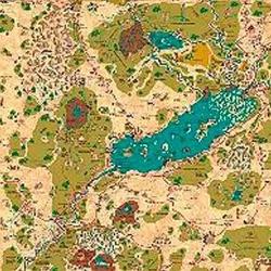
Country of Arduin Map
A full 2 x 3 ft, four-color poster map of Arduin, reproduced from David Hargrave’s original hand-drawn maps on parchment-style paper. It shows roads, cities, towns, villages, forests, named mountains, swamps, islands, seas, lakes, and other major geography, with a legend and scale included. The map is rolled and shipped in a tube.
Založeno na atributech/statistikách (STR, CON, PER atd.)Založeno na úrovních (získávejte XP a postupujte na vyšší úroveň)Založeno na třídách (pilot, čaroděj, vědec atd.)
O hře
- Autoři
- Ilustrace
- Vydavatel

Rozšíření pro
Zobrazit v Ludoya

Zdarma, na webu, Androidu i iOS
Hrajte Country of Arduin Map s Ludoya
- Mějte ji ve své sbírceEvidujte svůj výtisk a jeho rozšíření, půjčujte ho přátelům, nebo si ho dejte na seznam přání a dozvíte se, když cena klesne.Přidat do sbírky
- Zapisujte každou partiiBody, vítězové, časovače a fotky, a pak vaše statistiky: úspěšnost, oblíbený počet hráčů, nejlepší skóre.Zapsat partii
- Počítejte body bez papíruPoužívejte výsledkové listy a herní pomocníky od komunity a nechte Ludoya sečíst body.Najít výsledkové listy
- Najděte lidi, se kterými ji zahrátKluby, herní večery a akce ve vašem okolí, kde se tato hra hraje.Zobrazit akce
Údaje o hře (hráči, herní doba, věk, autoři) z BoardGameGeek.