
2010 · Аксесоар (зарове, карти, екрани, карти за игра)
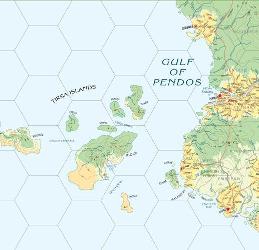
Atlas Hârnica Map C6
A regional map covering the northwestern coast of the Kingdom of Rethem, including the Gulf of Pendos and the Tirsa Islands. It shows settlements and keeps such as Tormau, Bedenes, Ithiko, Winen, Dasen, and Ithius, along with territories held by rival nobles, religious orders, Kuboran tribes, and pirates threatening coastal trade.
За играта
- Дизайн
- Илюстрации
- Издател


Разширение за
Виж ги в Ludoya
Безплатно, в уеб, Android и iOS
Играй Atlas Hârnica Map C6 с Ludoya
- Пази я в колекцията сиСледи своето копие и разширенията му, заеми го на приятели или го добави в списъка с желания и получи известие, когато цената падне.Добави я в колекцията си
- Записвай всяка партияТочки, победители, таймери и снимки, а после статистиката ти: процент на победи, любим брой играчи, най-добър резултат.Запиши партия
- Точки без хартияИзползвай листовете за резултати и помощниците за игра на общността и остави Ludoya да събере точките.Намери листове за резултати
- Намери с кого да я играешКлубове, игрални вечери и събития близо до теб, където тази игра е на масата.Виж събитията
Данни за играта (играчи, времетраене, възраст, автори) от BoardGameGeek.