
2010 · Accesoriu (zaruri, hărți, panouri, cărți)
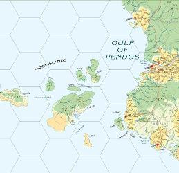
Atlas Hârnica Map C6
A regional map covering the northwestern coast of the Kingdom of Rethem, including the Gulf of Pendos and the Tirsa Islands. It shows settlements and keeps such as Tormau, Bedenes, Ithiko, Winen, Dasen, and Ithius, along with territories held by rival nobles, religious orders, Kuboran tribes, and pirates threatening coastal trade.
Despre joc
- Design
- Ilustrație
- Editură

Extensie pentru
Vezi-le în Ludoya
Gratuit, pe web, Android și iOS
Joacă Atlas Hârnica Map C6 cu Ludoya
- Păstrează-l în colecția taȚine evidența exemplarului tău și a extensiilor lui, împrumută-l prietenilor sau pune-l pe lista de dorințe și află când scade prețul.Adaugă-l în colecția ta
- Înregistrează fiecare partidăPuncte, câștigători, cronometre și fotografii, apoi statisticile tale: rata de câștig, numărul preferat de jucători, cel mai bun scor.Înregistrează o partidă
- Ține scorul fără hârtieFolosește fișele de scor și ajutoarele de joc ale comunității și lasă Ludoya să adune punctele.Găsește fișe de scor
- Găsește oameni cu care să-l jociCluburi, seri de jocuri și evenimente de lângă tine unde se joacă acest joc.Vezi evenimentele
Datele jocului (jucători, durată, vârstă, autori) de pe BoardGameGeek.