
2016 · ملحق (نرد، خرائط، شاشات، بطاقات)
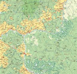
Atlas Hârnica Map F7: Kanday · Tharda
A regional fantasy map covering the heart of the Thardic Republic, including the settlements of Telen, Chenad, Hibut, Esuron, and Moleryn. It depicts the paved road between Coranan and Shiran, the Salt Route, and much of the Thard River, along with the Hefiosa Highlands. The wilds of Ramala Province feature the Teb Marshes, Mimea Hills, and Ramal Bog, home to the Gozyda tribes.
قائم على المهارات (شراء أو اكتساب مهارات)نرد (نسب مئوية)
عن اللعبة
- التصميم
- الرسوم
- دار نشر


توسعة لـ
شاهدها في Ludoya



مجاني، على الويب وAndroid وiOS
العب Atlas Hârnica Map F7: Kanday · Tharda مع Ludoya
- احتفظ بها في مجموعتكتابع نسختك وتوسعاتها، وأعرها لأصدقائك، أو أضفها إلى قائمة رغباتك ليصلك تنبيه عندما ينخفض السعر.أضفها إلى مجموعتك
- سجّل كل جلسة لعبالنقاط والفائزون والمؤقتات والصور، ثم إحصاءاتك: نسبة الفوز، وعدد اللاعبين المفضل، وأفضل نتيجة.سجّل جلسة لعب
- احسب النقاط بلا ورقاستخدم أوراق النقاط وأدوات اللعب من المجتمع، ودع Ludoya يجمع النقاط.ابحث عن أوراق النقاط
- اعثر على من تلعبها معهمأندية وأمسيات ألعاب وفعاليات قريبة منك تلعب هذه اللعبة.عرض الفعاليات
معلومات اللعبة (اللاعبون، مدة اللعب، العمر، فريق العمل) مأخوذة من BoardGameGeek.