
2005 · ملحق (نرد، خرائط، شاشات، بطاقات)
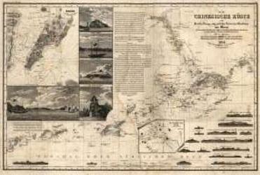
Hong Kong of the 1800's
An antique-style nautical chart depicting Hong Kong and Macao in the early 1800s. It shows harbor approaches, waterway soundings, bearings, island silhouettes, Macao’s street plan, and illustrations of prominent sites. The map measures 73 by 49 inches and is suitable for display as a poster or background.
- اللاعبون
- 0
عن اللعبة
- التصميم
- الرسوم
- دار نشر

توسعة لـ
شاهدها في Ludoya
مجاني، على الويب وAndroid وiOS
العب Hong Kong of the 1800's مع Ludoya
- احتفظ بها في مجموعتكتابع نسختك وتوسعاتها، وأعرها لأصدقائك، أو أضفها إلى قائمة رغباتك ليصلك تنبيه عندما ينخفض السعر.أضفها إلى مجموعتك
- سجّل كل جلسة لعبالنقاط والفائزون والمؤقتات والصور، ثم إحصاءاتك: نسبة الفوز، وعدد اللاعبين المفضل، وأفضل نتيجة.سجّل جلسة لعب
- احسب النقاط بلا ورقاستخدم أوراق النقاط وأدوات اللعب من المجتمع، ودع Ludoya يجمع النقاط.ابحث عن أوراق النقاط
- اعثر على من تلعبها معهمأندية وأمسيات ألعاب وفعاليات قريبة منك تلعب هذه اللعبة.عرض الفعاليات
معلومات اللعبة (اللاعبون، مدة اللعب، العمر، فريق العمل) مأخوذة من BoardGameGeek.