
2016 · Kiegészítő (dobókockák, térképek, képernyők, kártyák)
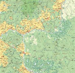
Atlas Hârnica Map F7: Kanday · Tharda
A regional fantasy map covering the heart of the Thardic Republic, including the settlements of Telen, Chenad, Hibut, Esuron, and Moleryn. It depicts the paved road between Coranan and Shiran, the Salt Route, and much of the Thard River, along with the Hefiosa Highlands. The wilds of Ramala Province feature the Teb Marshes, Mimea Hills, and Ramal Bog, home to the Gozyda tribes.
Készségalapú (készségek vásárlása vagy megszerzése)Kockák (percentilis)
A játékról
- Tervezés
- Grafika
- Kiadó


Kiegészítő ehhez:
Nézd meg őket a Ludoyában



Ingyenes, weben, Androidon és iOS-en
Játszd a(z) Atlas Hârnica Map F7: Kanday · Tharda játékot a Ludoyával
- Tartsd a gyűjteményedbenKövesd a példányodat és a kiegészítőit, add kölcsön a barátaidnak, vagy tedd fel a kívánságlistádra, és szólunk, ha csökken az ára.Add hozzá a gyűjteményedhez
- Rögzíts minden játszmátPontok, győztesek, időzítők és fotók, aztán a statisztikáid: győzelmi arány, kedvenc játékosszám, legjobb pontszám.Játszma rögzítése
- Pontozz papír nélkülHasználd a közösség pontozólapjait és játéksegédeit, és a Ludoya összeadja a pontokat.Pontozólapok keresése
- Találj játszótársakat hozzáKlubok, játékestek és események a közeledben, ahol ez a játék asztalra kerül.Események megtekintése
Játékadatok (játékosok, játékidő, kor, alkotók) forrása: BoardGameGeek.