
2000 · Kiegészítő (dobókockák, térképek, képernyők, kártyák)
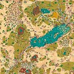
Country of Arduin Map
A full 2 x 3 ft, four-color poster map of Arduin, reproduced from David Hargrave’s original hand-drawn maps on parchment-style paper. It shows roads, cities, towns, villages, forests, named mountains, swamps, islands, seas, lakes, and other major geography, with a legend and scale included. The map is rolled and shipped in a tube.
Attribútum-/statisztikaalapú (STR, CON, PER stb.)Szintalapú (XP szerzés és szintlépés)Osztályalapú (pilóta, varázsló, tudós stb.)
A játékról
- Tervezés
- Grafika

Kiegészítő ehhez:
Nézd meg őket a Ludoyában

Ingyenes, weben, Androidon és iOS-en
Játszd a(z) Country of Arduin Map játékot a Ludoyával
- Tartsd a gyűjteményedbenKövesd a példányodat és a kiegészítőit, add kölcsön a barátaidnak, vagy tedd fel a kívánságlistádra, és szólunk, ha csökken az ára.Add hozzá a gyűjteményedhez
- Rögzíts minden játszmátPontok, győztesek, időzítők és fotók, aztán a statisztikáid: győzelmi arány, kedvenc játékosszám, legjobb pontszám.Játszma rögzítése
- Pontozz papír nélkülHasználd a közösség pontozólapjait és játéksegédeit, és a Ludoya összeadja a pontokat.Pontozólapok keresése
- Találj játszótársakat hozzáKlubok, játékestek és események a közeledben, ahol ez a játék asztalra kerül.Események megtekintése
Játékadatok (játékosok, játékidő, kor, alkotók) forrása: BoardGameGeek.