
2004 · Akcesorium (kości, mapy, ekrany, karty)
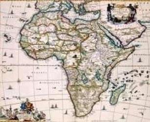
Africa of the 1600's
A decorative historical map depicting Africa as charted by Niccolaas Visscher II around 1681. The coastlines are shown in greater detail, while much of the interior remains unexplored and marked with period-era geography, making it suitable for 17th-century role-playing settings, lost empires, and exploration scenarios. The printed map measures approximately 55.5 by 45 inches and can also be used as wall décor.
- Gracze
- 0
O grze
- Projekt
- Grafika
- Wydawca

Dodatek do
Zobacz je w Ludoya
Za darmo, w przeglądarce, na Androidzie i iOS
Graj w Africa of the 1600's z Ludoya
- Miej ją w swojej kolekcjiŚledź swój egzemplarz i jego dodatki, pożyczaj go znajomym albo dodaj go do listy życzeń i dostań powiadomienie, gdy cena spadnie.Dodaj do swojej kolekcji
- Zapisuj każdą rozgrywkęPunkty, zwycięzcy, minutniki i zdjęcia, a potem twoje statystyki: procent zwycięstw, ulubiona liczba graczy, najlepszy wynik.Zapisz rozgrywkę
- Licz punkty bez papieruKorzystaj z arkuszy wyników i pomocy do gry od społeczności i pozwól Ludoya zsumować punkty.Znajdź arkusze wyników
- Znajdź ludzi do wspólnej gryKluby, wieczory gier i wydarzenia w pobliżu, na których ta gra trafia na stół.Zobacz wydarzenia
Dane gry (gracze, czas gry, wiek, twórcy) z BoardGameGeek.