
2004 · Аксессуар (кубики, карты, экраны, карточки)
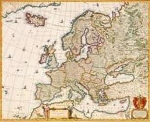
Europe of the 1600's
A historical map depicting Europe as understood by Niccolaas Visscher I in the 1600s. It shows countries, towns, cities, and borders of the period, and reflects the atlas index maps used at the time. The print measures 55.3 inches wide by 44.5 inches high.
- Игроки
- 0
Об игре
- Автор
- Иллюстрации
- Издательство

Дополнение к
Смотреть в Ludoya
Бесплатно, в браузере, на Android и iOS
Играйте в Europe of the 1600's с Ludoya
- Держите её в своей коллекцииОтслеживайте свой экземпляр и его дополнения, давайте его друзьям или добавьте в список желаний и узнайте, когда цена упадёт.Добавить в коллекцию
- Записывайте каждую партиюОчки, победители, таймеры и фото, а затем ваша статистика: процент побед, любимое число игроков, лучший результат.Записать партию
- Считайте очки без бумагиПользуйтесь листами подсчёта очков и помощниками для игры от сообщества, а очки пусть считает Ludoya.Найти листы подсчёта
- Найдите, с кем в неё сыгратьКлубы, игровые вечера и мероприятия рядом с вами, где играют в эту игру.Смотреть мероприятия
Сведения об игре (игроки, время партии, возраст, авторы) взяты с BoardGameGeek.