
2000 · Tilbehør (terninger, kort, skærme, spillekort)
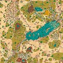
Country of Arduin Map
A full 2 x 3 ft, four-color poster map of Arduin, reproduced from David Hargrave’s original hand-drawn maps on parchment-style paper. It shows roads, cities, towns, villages, forests, named mountains, swamps, islands, seas, lakes, and other major geography, with a legend and scale included. The map is rolled and shipped in a tube.
Attribut-/statbaseret (STR, CON, PER osv.)Niveaubaseret (optjen XP og stig i niveau)Klassesystem (Pilot, Troldmand, Videnskabsmand osv.)
Om spillet
- Design
- Illustration
- Udgiver

Udvidelse til
Se dem i Ludoya

Gratis, på web, Android og iOS
Spil Country of Arduin Map med Ludoya
- Hav det i din samlingHold styr på dit eksemplar og dets udvidelser, lån det ud til venner, eller sæt det på din ønskeliste, og få besked, når prisen falder.Føj det til din samling
- Registrér hvert partiPoint, vindere, timere og fotos, og så din statistik: vinderprocent, foretrukket spillerantal, bedste score.Registrér et parti
- Hold score uden papirBrug fællesskabets scoringsark og spilhjælpere, og lad Ludoya lægge pointene sammen.Find scoringsark
- Find nogen at spille det medKlubber, spilaftener og arrangementer nær dig, hvor dette spil kommer på bordet.Se arrangementer
Spilfakta (spillere, spilletid, alder, medvirkende) fra BoardGameGeek.