
2006 · アクセサリー(ダイス、マップ、スクリーン、カード)
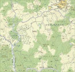
Atlas Hârnica Map J6
A regional map covering southwestern Kaldor and parts of Evael, the Elven Kingdom. It shows Jedes Keep, the only major civilized settlement, along with Pagaelin villages and the native names of lakes and rivers. The map features the Oselmarch, claimed by Kaldor but controlled by Pagaelin tribesmen, as well as the impassable Tuleme Falls and the extensive Linor Bog. The Shomos River forms the southern boundary.
ゲームについて
- デザイン


拡張の対象
Ludoyaで見る
ゲーム情報(人数、プレイ時間、対象年齢、クレジット)の出典:BoardGameGeek。