
2011 · Tilbehør (terninger, kart, skjermer, kort)
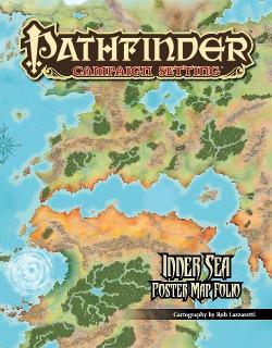
Inner Sea Poster Map Folio
A large poster map depicts the Inner Sea region of Golarion across four connected panels, measuring approximately 3½ feet wide by over 5 feet tall. Clear labels identify hundreds of towns, villages, castles, dungeons, and other locations from the Inner Sea World Guide, Adventure Paths, Modules, and the setting’s history. Printed on durable paper, it serves as a reference for planning and exploring campaigns.
Basert på attributter/statistikk (STR, CON, PER, osv.)Basert på nivåer (tjen XP og stig i nivå)Basert på klasser (pilot, trollmann, vitenskapsmann, osv.)
Om spillet
- Design
- Illustrasjon
- Utgiver


Utvidelse til
Se dem i Ludoya
På Ludoyas bord
All statistikk i Ludoya- 1
- I samlinger
Gratis, på nett, Android og iOS
Spill Inner Sea Poster Map Folio med Ludoya
- Ha det i samlingen dinHold oversikt over eksemplaret ditt og utvidelsene, lån det ut til venner, eller legg det på ønskelisten og få beskjed når prisen faller.Legg det til i samlingen din
- Registrer hver spilløktPoeng, vinnere, tidtakere og bilder, og så statistikken din: vinnerprosent, favorittantall spillere, beste poengsum.Registrer en spilløkt
- Før poeng uten papirBruk fellesskapets poengskjemaer og spillhjelpere, og la Ludoya legge sammen poengene.Finn poengskjemaer
- Finn folk å spille det medKlubber, spillkvelder og arrangementer nær deg der dette spillet kommer på bordet.Se arrangementer
Spillfakta (spillere, spilletid, alder, bidragsytere) fra BoardGameGeek.