
2000 · 액세서리(주사위, 지도, 스크린, 카드)
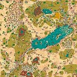
Country of Arduin Map
A full 2 x 3 ft, four-color poster map of Arduin, reproduced from David Hargrave’s original hand-drawn maps on parchment-style paper. It shows roads, cities, towns, villages, forests, named mountains, swamps, islands, seas, lakes, and other major geography, with a legend and scale included. The map is rolled and shipped in a tube.
속성/스탯 기반(STR, CON, PER 등)레벨 기반(XP를 획득하여 레벨업)클래스 기반(파일럿, 마법사, 과학자 등)


무료, 웹·Android·iOS 지원
Ludoya로 Country of Arduin Map 플레이하기
게임 정보(인원, 플레이 시간, 연령, 제작진) 출처: BoardGameGeek.