
2000 · Tillbehör (tärningar, kartor, skärmar, kort)
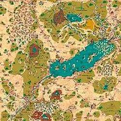
Country of Arduin Map
A full 2 x 3 ft, four-color poster map of Arduin, reproduced from David Hargrave’s original hand-drawn maps on parchment-style paper. It shows roads, cities, towns, villages, forests, named mountains, swamps, islands, seas, lakes, and other major geography, with a legend and scale included. The map is rolled and shipped in a tube.
Attribut-/statbaserat (STR, CON, PER, etc.)Nivåbaserat (tjäna XP och gå upp i nivå)Klassbaserat (pilot, trollkarl, forskare, etc.)
Om spelet
- Design
- Illustrationer
- Utgivare

Expansion till
Se dem i Ludoya

Gratis, på webben, Android och iOS
Spela Country of Arduin Map med Ludoya
- Ha det i din samlingHåll koll på ditt exemplar och dess expansioner, låna ut det till vänner, eller lägg det på din önskelista och få veta när priset sjunker.Lägg till i din samling
- Registrera varje spelomgångPoäng, vinnare, timers och foton, sedan din statistik: vinstprocent, favoritantal spelare, bästa poäng.Registrera en spelomgång
- Räkna poäng utan papperAnvänd communityns poängblad och spelhjälpmedel, och låt Ludoya räkna ihop poängen.Hitta poängblad
- Hitta folk att spela det medKlubbar, spelkvällar och evenemang nära dig där det här spelet kommer på bordet.Se evenemang
Speldata (spelare, speltid, ålder, medverkande) från BoardGameGeek.